Friday, March 27, 2020

Sites en route to Petra

Our next full day in Jordan was spent riding to Petra. However, we got to see several interesting places along the way. Our first stop was at the baptism site "Bethany Beyond the Jordan". On the way in, we had a bit of a distant look-see at Jabal Mar-Elias, which is Elijah's Hill. 


This is the place Elijah ascended to heaven in the 9th century BC - at the arch in the above pic. In the Bible in 2 Kings 2 it reads as follows: As they were walking along and talking together, suddenly a chariot of fire and horses of fire appeared and separated the two of them, and Elijah went up to heaven in a whirlwind. Elisha saw this and cried out, "My father! My father! The chariots and horsemen of Israel!" And Elisha* saw Elijah no more. Then he took hold of his garment and tore it in two.

*Elisha was a disciple of the prophet Elijah

The Bible states that Elijah would return before the coming of Jesus, so when John the Baptist began baptizing people in the Jordan, it caused a huge stir in the surrounding villages. In Matthew 3:11, John responded... "I baptize you with water for repentance. But after me comes one who is more powerful than I, whose sandals I am not worthy to carry. He will baptize you with the Holy Spirit and fire."

Jesus, the Messiah foreshadowed in the above passage, did indeed come to the Jordan from Galilee to see John the Baptist, where he was baptized. In verses 16-17 of this same chapter in Matthew, it reads as follows: As soon as Jesus was baptized, he went up out of the water. At that moment heaven was opened, and he saw the Spirit of God descending like a dove and alighting on him. And a voice from heaven said, "This is my Son, whom I love; with him I am well pleased."

What an amazing sight that must have been! It was declared a UNESCO World Heritage sight in 2015 as the place where Jesus was baptized and a pilgrimage site throughout history for Christians. The site includes a variety of modern day churches of different denominations, a monastery, baptismal pools, hermit cells, a pilgrim's station and the cave where John the Baptist may have lived.


The Jordan River no longer flows widely through here due to dam construction in the centuries since Jesus' baptism. 


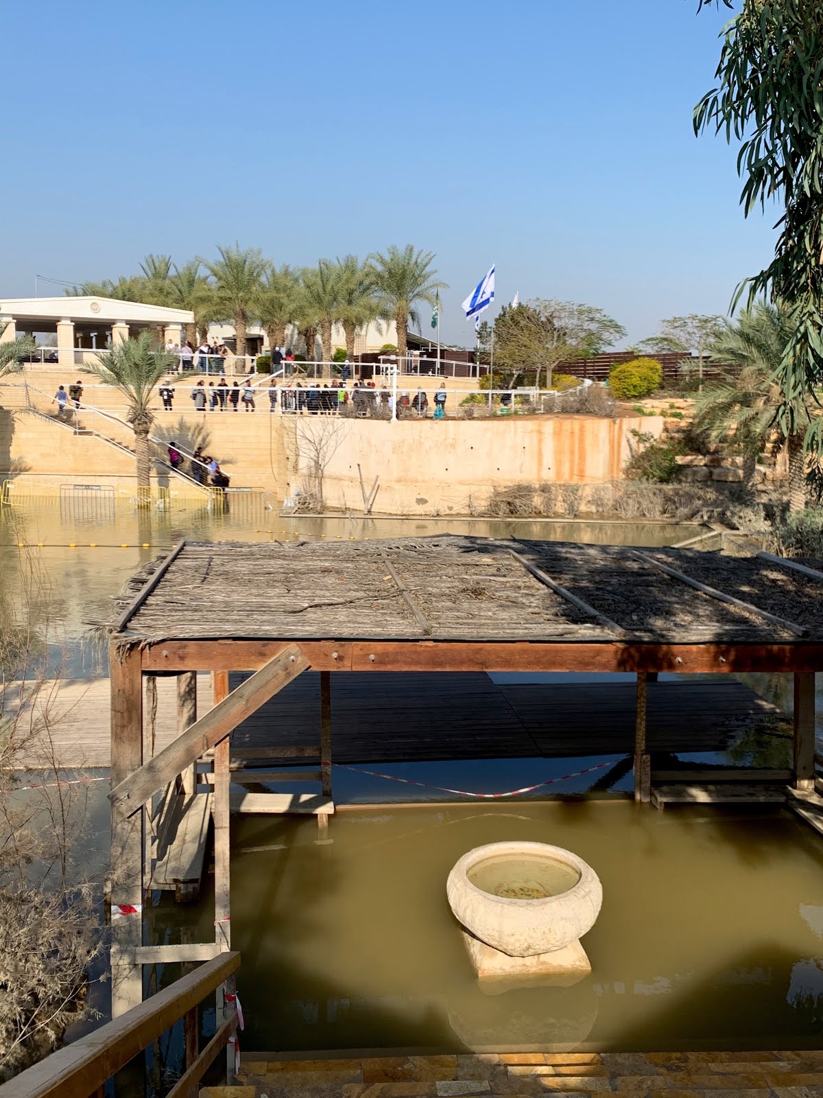
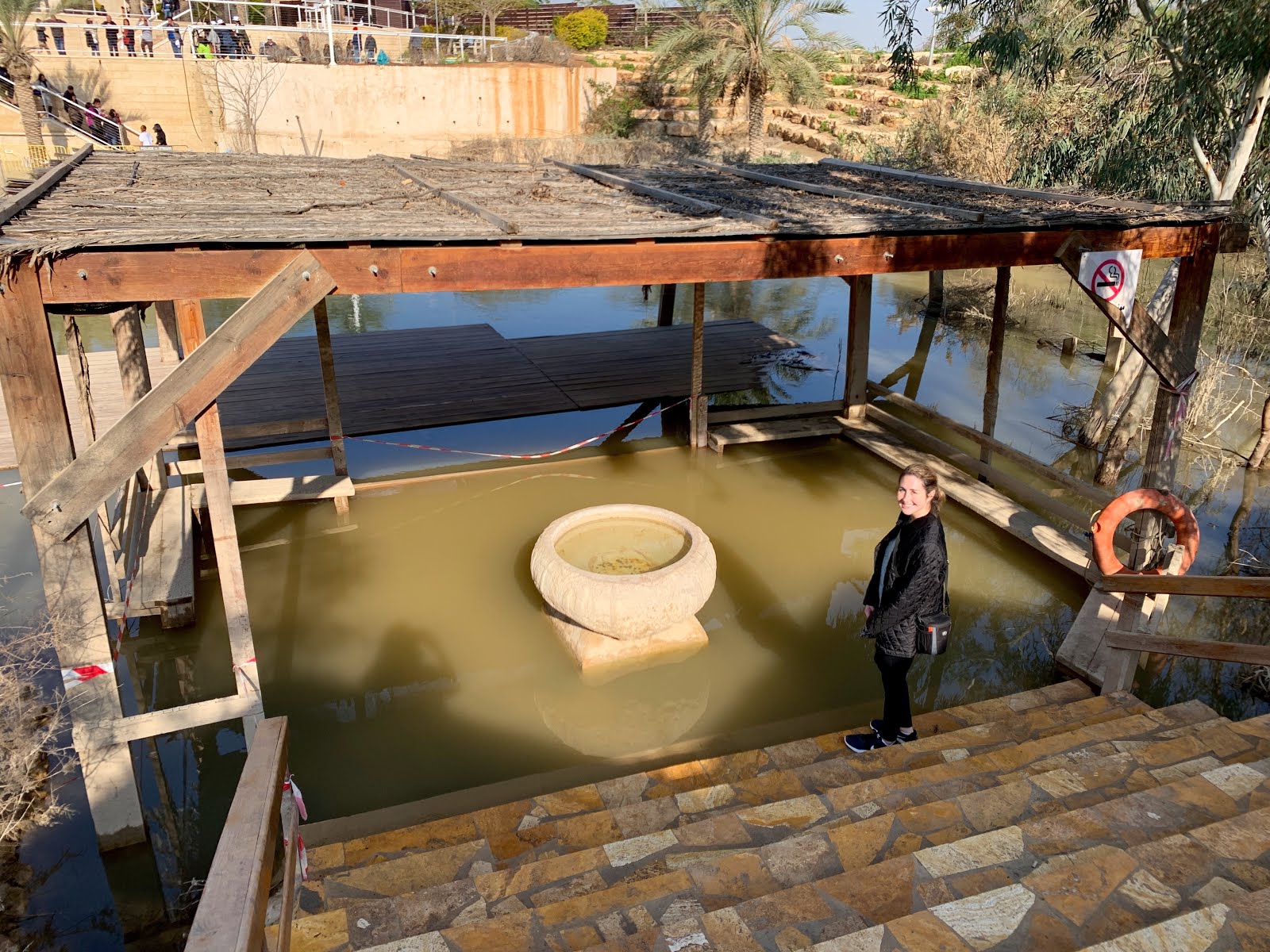
Above is the now covered remains of a church from the 5th century, with a separate baptistry that used the water of the Jordan for baptism. That's in the three pictures below. 


There is a cross carved into the stone down close to the bottom of the old baptism entry steps - do you see it? Below is the the modern stretch of the Jordan River where baptisms are currently held. Looking across from the Jordan side, you can see Israel on the opposite bank. The border between the two countries is in the middle of the river and you can just make out a long yellow floating line where it exists. On the Jordan side, there were few tourists. But across on the Israel side, we saw a couple folks being baptized despite the fact that the air temp wasn't quite 60F. That would have been a cold dunking!


Our next stop was historic Mt Nebo and another amazing biblical connection. After 40 years of leading the headstrong Israelites in the desert, Moses stood on the windswept summit of Mt Nebo and viewed the promised land of Canaan. In Deuteronomy 34 it reads: Then Moses climbed Mt Nebo... there the Lord showed him the whole land... Then the Lord said to him, "This is the land I promised on oath to Abraham, Isaac and Jacob when I said, 'I will give it to your descendants.' I have let you see it with your eyes, but you will not cross over into it." And Moses the servant of the Lord died there and was buried.

On a clear day, pilgrims and tourists can see the panorama Moses viewed, including the Dead Sea, the Jordan River valley, Jericho, Bethlehem, and the distant hills of Jerusalem.


Below, daughter A and I stood next to the modern serpentine cross sculpture. This is another biblical reference from the Old Testament about Moses. The sculpture resembles Moses' staff that produced water from a rock, turned into a snake and was used to part the Red Sea, all at God's will since He chose Moses to serve His purposes for the Israelites. The artist adapted the staff and serpent into a cruciform shape.


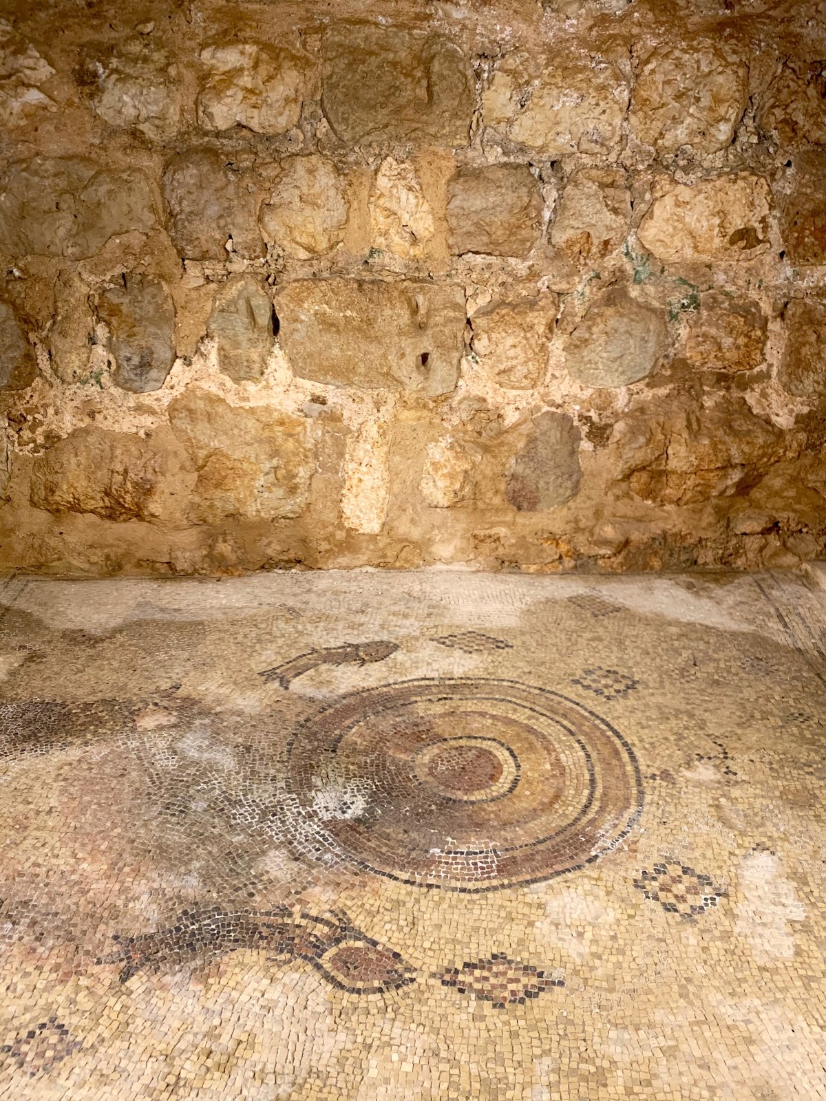
Atop Mt Nebo we toured some amazing mosaic floor remains. Early Christians from Jerusalem made Mt Nebo a place of pilgrimage. In the 3rd and 4th centuries, monks from Egypt built a small church to commemorate the life of Moses. This church was expanded in the 5th and 6th centuries into a large basilica with a stunning collection of Byzantine mosaics and an elaborate baptistry. These mosaics are now housed in a building with some catwalks so that you are able to get a good look at them. The main large mosaic depicts monastic wine-making, hunters and various animals.


In the 1930s, the Mt Nebo site was excavated, thanks largely to a description of it in the journal of an early pilgrim woman named Egeria in 394 AD. Our next stop was a mosaic workshop in Madaba where we got to see local artisans at work and even purchased a few handmade keepsake pieces that are still in the process of being shipped here to Texas. 


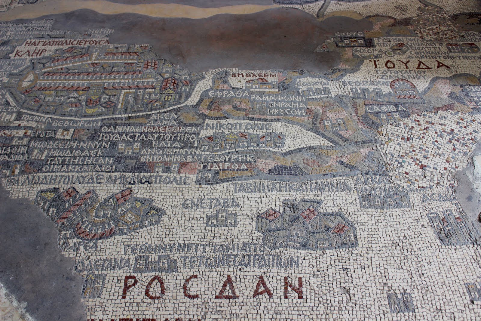
The final stop of our long driving day was at the Greek Orthodox Church of St George in old Madaba. This is the site of the famous mosaic floor map of the middle east during biblical times. 


This tile map is the oldest known geographic floor mosaic in existence, depicting the Middle East during the height of the Byzantine period. Installed sometime during the 6th century, many of the map's tiles have been chipped away or destroyed. 


The mosaic covers land from Egypt to Lebanon, including sites such as Bethlehem and Gethsemane, as well as Jerusalem. The Jerusalem portion of the map shows a number of specific structures and streets in the city, such as the Damascus Gate, the Church of the Holy Sepulcher and the Tower of David (top left corner in bottom pic of mosaic above).

Thursday, March 26, 2020

Jordan's Ajlun Castle

Following "lockdown" orders from the city/county for COVID-19 means I've got plenty of time on my hands to finish posting the rest of our February trip to Egypt and Jordan. Today I'm sharing our excursion to Ajlun Castle, which we visited after touring Jerash that morning.

Set atop the green hills of Gilead, Ajlun Castle is one of the great examples of Islamic Ayyubid military architecture in Jordan. Famous Muslim leader Saladin ordered construction of the castle high atop a hill in the 12th century AD around the time the Crusades ended. It was later enlarged by the Mamluks in the 13th century. Archaeological digs discovered that the castle was built atop the remains of a monastery from the Byzantine* period. 

 *In 330 AD, Roman Emperor Constantine chose Byzantium as the site of a "New Rome" and named the capital city Constantinople after himself. Five years earlier, the Council of Nicaea established Christianity - initially considered an obscure Jewish sect - as Rome's official religion. The citizens of Constantinople and the rest of the eastern Roman empire identified strongly as both Romans and Christians.


The castle was partially rebuilt after Mongol attacks later in the 13th century. The 52' wide moat is empty now, but you can still see the original arrow slits built into the walls to help fend off attacks. Plus we saw a collection of old stone cannonballs inside one of the rooms in the fort.


Serving utilitarian purposes since it was a fort, there were few decorative touches. The mosaic floor below is thought to have been a little chapel area where Christians were allowed to worship.


The view from the top was quite commanding, and easy to see why they chose this strategic site for construction. On a clear day, you can see to Syria, Lebanon and Israel.


From the Ottoman period forward, the castle contained only small contingents of soldiers. Two destructive earthquakes occurred in the 18th and 19th centuries, causing the damage still seen today. However, the castle has been sufficiently restored for tourist traffic.

The most puzzling thing I saw at the castle was this carved coffin just sitting out on a section of the entrance steps. There was no placard to explain anything about it. It was as if it had just randomly dropped out of the sky. I couldn't help but wonder if it was buried there when the site was still a Christian monastery and discovered in one of the archaeological digs.


Wednesday, March 25, 2020

Jerash, Jordan

On our second full day in Jordan, we spent the morning touring the remains of Jerash. In ancient times, Jerash was one of the wealthiest and most cosmopolitan cities in the near east due to its prime location along trade routes. Settled as early as the 6th-7th century BC, and founded as a Hellenistic city in the 2nd century BC, today Jerash is noted for its fine Roman and Byzantine architecture. It was plain to see why it's considered some of the largest and best preserved Roman ruins outside of Rome.


The Romans sure did love a good column! And theaters - they're everywhere in the ancient world, these amazing places built to hold thousands for entertainment purposes.


Most of the structures still visible in Jerash today date from its Golden Age during the 2nd century AD. When Emperor Hadrian came to visit Jerash, this triumphal arch below was constructed in his honor and given his name.


The population of Jerash is thought to have been anywhere from 10-25,000 at the height of its prosperity. It's amazing to me that in addition to all of the structures, the ancient folks hand cut stone to lay down for roads. Literally thousands upon thousands of rocks laid all over to create walkways and roads  several millennia ago, much of it built at the command of Emperor Trajan. And check out the pics of a couple of the ancient manholes - unbelievable!


The teacher in me... seeing writing always makes me wish I could read it.


In this area of Jerash, seen below, was the ancient Roman version of La Cantera Mall here in San Antonio. It was an open air market, with vendors having a place to set up and sell their wares. You can still see the remains of an old fountain in the middle. Check out the animals carved into the still standing stones we saw at the back part of this section of the market - that was where the butcher was located.


The picture below illustrates where we were standing at one point in Jerash in relation to how the city functioned 2000 yrs ago. Looking down we could see an old olive oil press that would have used a donkey to turn it. However, it's now inaccessible due to time's dirt/debris covering it up. It's now located several yards below the current "level" of Jerash. Much of Jerash isn't visible because it's hidden under the soil. Or lying in pieces, waiting to be reconstructed.


Below are pictures of the remains of early Christian churches in Jerash. You can see bars across door access in the pics. We were only allowed to view the churches from above since folks had started stealing tiles from the mosaic floor for keepsakes.


It is unknown when Christianity arrived in Jerash. However, Jerash did serve as the residence of a bishopric, who is recorded to have attended the Council of Seleucia in 359 AD. By the 6th century AD, Jerash contained fifteen churches. The oldest church - the two pics above - is Jerash's cathedral, which dates to the late 4th century AD. The mosaic floor below was located in a separate church.


There is also at least one Biblical connection to Jerash I discovered. Jerash was known as Gerasa or Gerash in Biblical times, and is mentioned in Mark 5 and Luke 8 when "Jesus Restores a Demon-Possessed Man." It reads as follows in Luke 8:26... "They sailed to the region of the Gerasenes, which is across the lake from Galilee." In the story it mentions the demon-possessed man lived in the tombs in this area. Below is a picture I took of one of the tombs I saw in Jordan.


Alas, Jerash fell victim to the winds of change. The Persians captured, plundered and occupied Jerash in the earlier part of the 7th century AD. By the time the armies of the Arabs arrived a few years after that, they surrendered immediately because they were so weakened. New trade routes began to bypass this region, wealthier citizens moved to follow the money and thus began a period of steep decline in Jerash. In the early middle ages, a series of earthquakes made the city uninhabitable and it was abandoned. Excavations in Jerash began in the 1920s, and much is still yet to be unearthed to better understand its history.